Potential Gulf Hurricane: Invest 92L & Weekend Power Outage Risks
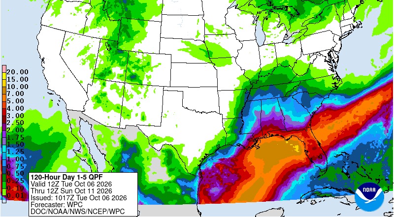
A developing tropical system in the southwestern Gulf of Mexico is commanding the attention of meteorologists and utility operators across the southern United States. As of Tuesday, October 6, 2026, the National Hurricane Center (NHC) has tagged the disturbance as Invest 92L and increased its development odds to a 90% chance of forming into a tropical depression within the next 48 hours.
Atmospheric models project the system will drift slowly eastward midweek before taking a sharp turn northward toward the northern Gulf Coast late this week and over the weekend (October 9–11). If the system organizes with sustained winds of 39 mph or higher, it will be designated Tropical Storm Isaias — with several intensity models flagging potential intensification into a hurricane over warm October Gulf waters.
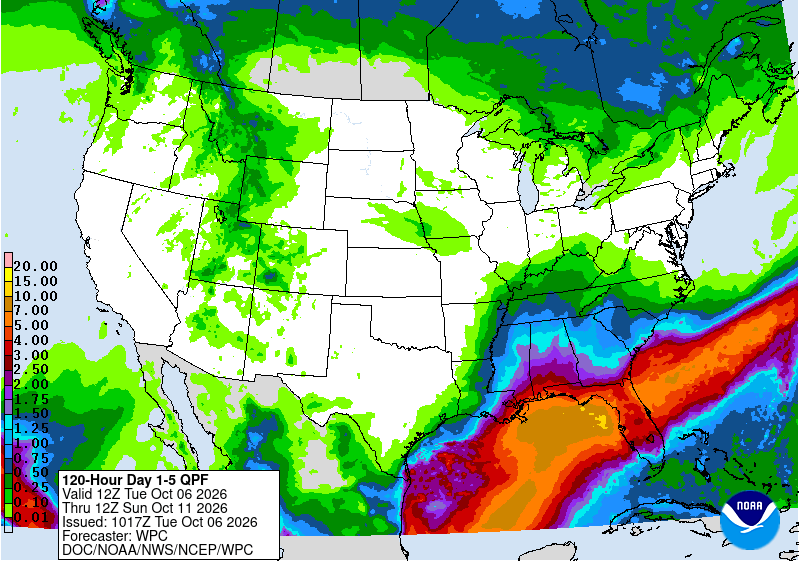
Regardless of whether the storm makes landfall as a tropical storm or hurricane, the energy infrastructure across Louisiana, Mississippi, Alabama, and Florida faces major threats: torrential rain of 5 to 10+ inches, coastal storm surge, saturated soil leading to falling trees, and significant risk of widespread, multi-day electrical outages.
Current Conditions: What Meteorologists Are Seeing
As of Tuesday morning, October 6, 2026, the disturbance consists of a broad low-pressure area over the southwestern Gulf of Mexico (the Bay of Campeche). Satellite imagery reveals concentrated showers and thunderstorms wrapping around an elongating center of circulation, with maximum sustained winds already near 30 mph and a central atmospheric pressure of approximately 1009 millibars.
The National Hurricane Center noted that environmental conditions, while marginally shear-dominated initially, are increasingly supportive of tropical cyclogenesis:
“Showers and thunderstorms are showing signs of organization in association with a broad area of low pressure located over the southwestern Gulf. Continued development of this system is expected, and a tropical depression is anticipated to form over the next day or so while it drifts eastward... The disturbance is expected to turn to the north or northeast toward the northern Gulf Coast by the end of the week.”
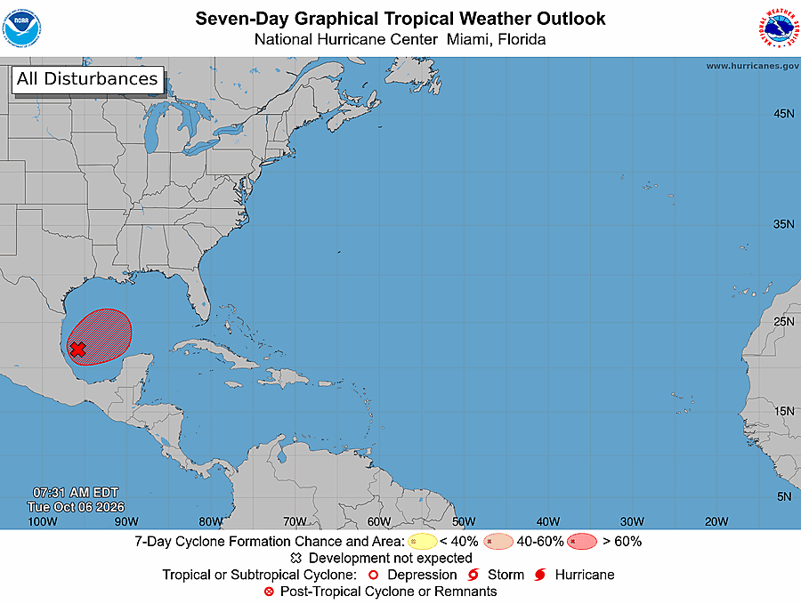
Reconnaissance missions are underway to get precise, real-time measurements:
- NOAA Gulfstream IV Jet (“Gonzo”): Tasked to fly high-altitude dropsondes (up to 45,000 feet) on Tuesday afternoon to sample the Tropical Upper Tropospheric Trough (TUTT) and steering currents surrounding the system.
- U.S. Air Force Reserve Hurricane Hunters: WC-130J aircraft out of Keesler AFB in Biloxi, MS, are scheduled for low-altitude penetration into the center of circulation Wednesday to assess whether a closed surface low has formed.
Forecast Track & Timing: The Path to the Northern Gulf
Computer models (including the GFS, ECMWF/European, UKMET, and regional hurricane models) agree on the overall synoptic evolution, though the exact point of landfall will not solidify until a discrete low-level center forms.
Wednesday, Oct 7 — Slow Drift in the Bay of Campeche
The system remains quasi-stationary or drifts slowly eastward across the southern Gulf. Heavy outer squalls will lash the western Yucatán Peninsula and coastal Mexico (Campeche, Tabasco, and Veracruz). Upgrading to a Tropical Depression or Tropical Storm Isaias is likely during this period.
Thursday, Oct 8 — The Northward Turn
A digging upper-level trough and associated autumn cold front moving across the central United States will capture the tropical system, breaking down the subtropical ridge and accelerating the storm north or north-northeastward across the central Gulf of Mexico.
Friday, Oct 9 through Sunday, Oct 11 — Weekend Northern Gulf Impact
The storm will approach the northern Gulf Coast. Peak landfall windows range from late Friday night into Saturday morning, October 10. The highest-risk landfall zone stretches from southeast Louisiana (Plaquemines and St. Bernard parishes) eastward across coastal Mississippi (Gulfport/Biloxi), coastal Alabama (Mobile Bay, Dauphin Island, Baldwin County), and into the Florida Panhandle (Pensacola, Fort Walton Beach, Destin, Panama City, and the Big Bend).
Will Invest 92L Become a Hurricane?
Meteorologists are debating the storm’s potential intensity due to two competing atmospheric forces:
1. Ocean Fuel: Exceptionally Warm Gulf Waters
Early October water temperatures across the central and eastern Gulf of Mexico remain between 84°F and 86°F (29°C–30°C), well above the 80°F threshold necessary to support intense tropical cyclones. Deep ocean heat content in the Gulf Loop Current provides abundant thermal energy for rapid development if convective storms consolidate around the core.
2. Atmospheric Brake: Approaching Wind Shear
As the storm progresses into the northern Gulf on Friday, it will encounter increasing southwesterly vertical wind shear (20 to 35+ knots) generated by the approaching continental jet stream. Strong wind shear tilts the vortex and injects dry air into the storm core, which could cap intensity and prevent the storm from reaching major hurricane status.
Meteorologists currently place the chance of Invest 92L reaching hurricane strength (sustained winds of 74+ mph) at approximately 20% to 35%. However, forecasters emphasize that intensity classification does not dictate damage: an asymmetric, sheared tropical storm or subtropical system can dump just as much water and knock down just as many trees as a minimal Category 1 hurricane.
Potential Weekend Impacts: State-by-State Grid & Outage Risks
The electric utility sector is mobilizing mutual-aid crews across the Gulf Coast. Saturated soils from earlier autumn rain events combined with prolonged tropical-force winds create ideal conditions for tree uprooting and distribution feeder failures.
| State / Region | Key Electric Utilities | Primary Grid Vulnerabilities & Outage Drivers |
|---|---|---|
| Louisiana (Southeast & River Parishes) | Entergy Louisiana, Entergy New Orleans, Cleco | Low-elevation substation flooding along coastal bayous (Terrebonne, Lafourche, Plaquemines). Saturated ground can down trees onto distribution poles throughout the New Orleans metro and Northshore. |
| Mississippi (Gulf Coast & Pine Belt) | Mississippi Power (Southern Co.), Entergy Mississippi, Coast Electric | Dense pine timber corridors are notorious for falling across distribution circuits during tropical storm-force gusts. Coastal surge along the Mississippi Sound and river backwater flooding. |
| Alabama (Mobile & Baldwin Counties) | Alabama Power, Baldwin EMC, Riviera Utilities | Funneling storm surge into Mobile Bay poses salt-water contamination risks to low-lying electrical equipment. Heavy rain bands triggering urban flash flooding and downed oak limbs. |
| Florida Panhandle & Big Bend | Florida Power & Light (FPL Northwest), Duke Energy Florida, Gulf Coast Electric, CHELCO | Sandy coastal soils lose structural integrity quickly under 6–10 inches of rain, allowing utility poles to lean or fall. Apalachee Bay is extremely vulnerable to shallow-water storm surge. |
Why Tropical Flooding Battered Utilities More Than High Wind
When consumers think of hurricanes, they imagine wind ripping roof shingles and toppling towers. But power company emergency managers know that water is often the far deadlier enemy of electrical equipment:
Substation Flooding & Preemptive De-Energization
High-voltage substations contain delicate relays, transformers, and switchgear. When saltwater storm surge or freshwater river flooding reaches substation yards, water creates catastrophic short circuits and destroys multi-million-dollar components that take months to replace. Consequently, utilities will deliberately de-energize flooded substations before water arrives, cutting power to tens of thousands of homes to preserve the grid’s long-term hardware.
The Root-Failure Threshold
A 45 mph tropical storm gust on dry soil rarely causes serious damage. But when the ground absorbs 6 to 10 inches of rain, the root zones of mature pine, water oak, and live oak trees become liquefied mud. Under saturated conditions, modest 40–50 mph wind gusts can easily topple large trees across primary three-phase feeders, snapping utility poles and causing localized power outages that take days for line crews to physically clear and re-string.
Salt Contamination on Insulators
Along the immediate coastline, onshore tropical winds carry airborne ocean sea spray miles inland. Salt deposits coat ceramic and polymer line insulators. When light rain or morning humidity mixes with the salt crust, it creates an electrical bridge (“tracking”), causing sparks, blown fuses, and pole-top fires even after the storm has passed.
Weekend Storm Preparation: Electrical Safety Checklist
Residents from southeastern Louisiana through northern Florida should complete their basic tropical weather preparations by Thursday evening before squalls arrive Friday morning:
Energy Markets & Grid Reliability
Beyond localized power outages, tropical storms in the Gulf of Mexico have broader repercussions for the nation’s energy supply chain:
- Offshore Production Shut-Ins: Energy producers with platforms in the central and western Gulf (including Shell, BP, and Chevron) are monitoring Invest 92L. While the storm is centered east of the densest offshore oil and natural gas fields, safety evacuations of non-essential personnel can temporarily reduce Gulf natural gas output.
- Wholesale Market Pricing: Storm disruptions to transmission corridors and natural gas pipelines into Florida and the Southeast can cause temporary price spikes in regional wholesale electricity markets. In competitive electricity states, weather shocks demonstrate the value of fixed-rate contracts that protect residential and commercial buyers against volatile spot energy spikes.
What’s Next?
Over the next 24 to 48 hours, hurricane hunters and satellite data will clarify whether Invest 92L consolidates into Tropical Storm Isaias and where the primary rain and wind core will track. Residents along the northern Gulf Coast should review their emergency plans, secure outdoor patio items that could become airborne projectiles, and monitor official forecasts closely.
Our team will monitor the storm’s evolution and its impacts on the electrical grid in real time. For up-to-the-minute outage figures across Louisiana, Mississippi, Alabama, Florida, and nationwide, bookmark our Live Power Outage Tracker.
Sources & References
National Hurricane Center (NHC) Miami, FL — Tropical Weather Outlook (issued 8:00 AM EDT Oct 6, 2026; Forecaster Cangialosi); NOAA Weather Prediction Center (WPC) Quantitative Precipitation Forecasts; National Weather Service forecast offices in Slidell/New Orleans, Mobile/Pensacola, and Tallahassee; Entergy, Mississippi Power, Alabama Power, Florida Power & Light storm readiness advisories. Information is current as of publication and may change as the system develops.